How it Works:
The GeoToll mobile payment solution consists of an application downloaded to your smartphone. Upon activation, it starts to send GPS information to pinpoint the vehicle’s location around the toll plazas according to the user’s privacy choice.
A server collects and enhances GPS information from each customer’s smartphone application. It then compares the GPS information captured from customer’s smartphones with predetermined boundaries on the toll plazas, defined as toll geofences.
When the GeoToll server determines that a vehicle associated with a particular smartphone has driven within a toll geofence, the server uses that information to charge the toll amount to the payment processor also residing in the application for multiple types of payments and debt transactions.
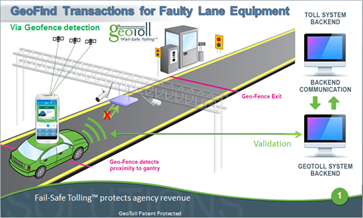
Presently, all toll agencies experience revenue loss due to malfunctioning lane equipment and non-recognition of license plates.
The GeoToll Fail-Safe Tolling® with enhanced GPS and machine learning algorithms for improved location accuracy validates the transaction independent of lane equipment failure or non-recognition of license plates; this is defined as a GeoFind™ transaction, as shown below: